WaterProtect - Irish Actionlab
The Irish Actionlab, led by Teagasc in collaboration with the Irish Agricultural Catchments Programme (ACP) , Wexford County Council, Glanbia and Ulster University consists of two projects aimed at assessing the efficacy, uptake and implementation of mitigation measures, to protect water resources in rural agricultural environment. Both projects will be carried out within County Wexford, SE Ireland with focus on two data rich river catchments (ca. 11 km2), both of which are part of ACP.
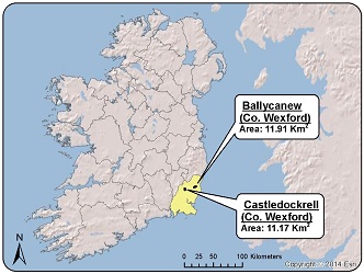 One of the catchments Castledockrell has mostly free draining soils overlaying fissured slate bedrock and is dominated by arable land (65%), while the other Ballycanew has mostly poorly drained soils overlaying volcanic rhyolite and is dominated by grassland (75%) for beef and dairy production. The free draining arable land is largely groundwater fed and risky for leaching of nutrients and pesticides to groundwater while the poorly drained grassland has a flashy hydrology and is risky for nutrient loss via runoff to surface water and quick shifts in weather. Both catchments have small scale abstraction of groundwater to supply individual farms. Additionally, a small number of households within the catchment have common water supply from groundwater within the catchments.
Project 1: Assessing the efficacy of mitigation measures
A suite of intervention measures for mitigating nitrate and pesticide loss to water will be identified and tested at the field scale in high risk areas on commercial farms. The work will build on the detailed understanding of pollutant mobilisation and transfer processes gained from different physical settings within the ACP and will be backed up by supportive data from the existing infrastructure. Bio-geo-physical aspects of cost effective, multi-beneficial and realistic intervention measures for nitrate and pesticides (mainly MCPA and its metabolites) for Irish agri-climatic conditions will be identified and place the Irish Actionlab into EU perspective. The efficacy of identified measures to mitigate nitrate and pesticides from reaching water will be quantified in focused study sites with a detailed and direct ‘before and after’ monitoring of surface and groundwater. Methods aimed at managing source, intercepting pathways and remediating delivery points will be assessed. The results will be examined at ACP catchment scale (ca. 10 km2) and river basin scale (ca. 100 km2) for further test of realistic land use change scenarios.